


Zeandale Township Voting District, Riley County, Kansas
About
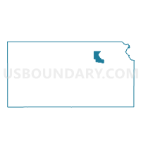
Outline

Summary
| Unique Area Identifier | 586494 |
| Name | Zeandale Township Voting District |
| County | Riley County |
| State | Kansas |
| Area (square miles) | 60.19 |
| Land Area (square miles) | 59.72 |
| Water Area (square miles) | 0.47 |
| % of Land Area | 99.22 |
| % of Water Area | 0.78 |
| Latitude of the Internal Point | 39.09332270 |
| Longtitude of the Internal Point | -96.47004720 |
Maps


Graphs
Select a template below for downloading or customizing gragh for Zeandale Township Voting District, Riley County, Kansas


Neighbors
Neighoring Voting District (by Name) Neighboring Voting District on the Map
- Alma Township Voting District, Wabaunsee County, KS
- Ashland Township Voting District, Riley County, KS
- Blue Township Voting District, Pottawatomie County, KS
- Jackson Township Voting District, Geary County, KS
- Manhattan Township Precinct 2, Riley County, KS
- St. George Township Voting District, Pottawatomie County, KS
- Wabaunsee Township Voting District, Wabaunsee County, KS
- Washington Township Voting District, Wabaunsee County, KS
Top 10 Neighboring County Subdivision (by Population) Neighboring County Subdivision on the Map
- St. George township, Pottawatomie County, KS (3,415)
- Blue township, Pottawatomie County, KS (3,046)
- Manhattan township, Riley County, KS (2,444)
- Alma township, Wabaunsee County, KS (1,191)
- Wabaunsee township, Wabaunsee County, KS (524)
- Zeandale township, Riley County, KS (341)
- Ashland township, Riley County, KS (139)
- Washington township, Wabaunsee County, KS (76)
- Jackson township, Geary County, KS (59)
Top 10 Neighboring Unified School District (by Population) Neighboring Unified School District on the Map
- Manhattan Unified School District 383, KS (60,134)
- Geary County Schools Unified School District 475, KS (41,928)
- Wamego Unified School District 320, KS (7,419)
- Rock Creek Unified School District 323, KS (5,026)
- Mill Creek Valley Unified School District 329, KS (3,584)
Top 10 Neighboring State Legislative District Lower Chamber (by Population) Neighboring State Legislative District Lower Chamber on the Map
- State House District 67, KS (24,852)
- State House District 61, KS (24,567)
- State House District 65, KS (22,589)
- State House District 51, KS (22,133)
Top 10 Neighboring State Legislative District Upper Chamber (by Population) Neighboring State Legislative District Upper Chamber on the Map
- State Senate District 22, KS (95,140)
- State Senate District 1, KS (69,919)
- State Senate District 18, KS (67,438)
Top 10 Neighboring 111th Congressional District (by Population) Neighboring 111th Congressional District on the Map
Top 10 Neighboring Census Tract (by Population) Neighboring Census Tract on the Map
- Census Tract 1, Pottawatomie County, KS (7,359)
- Census Tract 9, Riley County, KS (5,707)
- Census Tract 2, Pottawatomie County, KS (5,549)
- Census Tract 4831, Wabaunsee County, KS (4,509)
- Census Tract 7, Geary County, KS (2,627)